Lake Erie Islands Water Trails
Explore Lake Erie by kayak or canoe on a series of scenic paddling routes around the islands and nearby mainland. From marshes and beaches to rocky shoreline, lighthouse views, and island landmarks, the Lake Erie Islands Water Trails offer a memorable way to experience Shores & Islands Ohio from the water.
What are the Lake Erie Islands Water Trails?
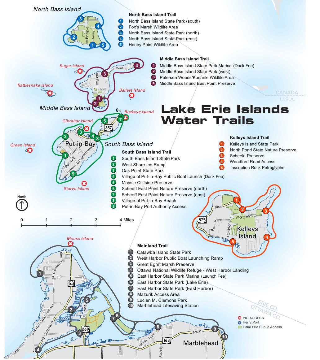
The Lake Erie Islands Water Trails are five mapped paddling areas that help visitors explore the islands and the nearby mainland by kayak or canoe. Together, they connect public access points with shoreline experiences that include wetlands, beaches, cliffs, village waterfronts, and quieter natural areas across the Lake Erie region.
Good to know before you launch
- The water trails include five paddling areas: Mainland, Kelleys Island, South Bass Island, Middle Bass Island, and North Bass Island.
- Access points identified in the trail materials are on public property. Visitors should respect private property along the rest of the shoreline.
- Some ferry service options may accommodate kayaks to certain islands for a fee. Travelers should confirm current policies directly before their trip.
- Open-water crossings between the mainland and islands, or between islands, are not recommended for novice paddlers.
- Lake Erie conditions can change quickly. Always check the forecast, marine conditions, and any active water quality advisories before launching.
- A properly fitted life jacket should be worn at all times. These planning and safety points are emphasized in the current page and guide.
Explore the five trail areas
-
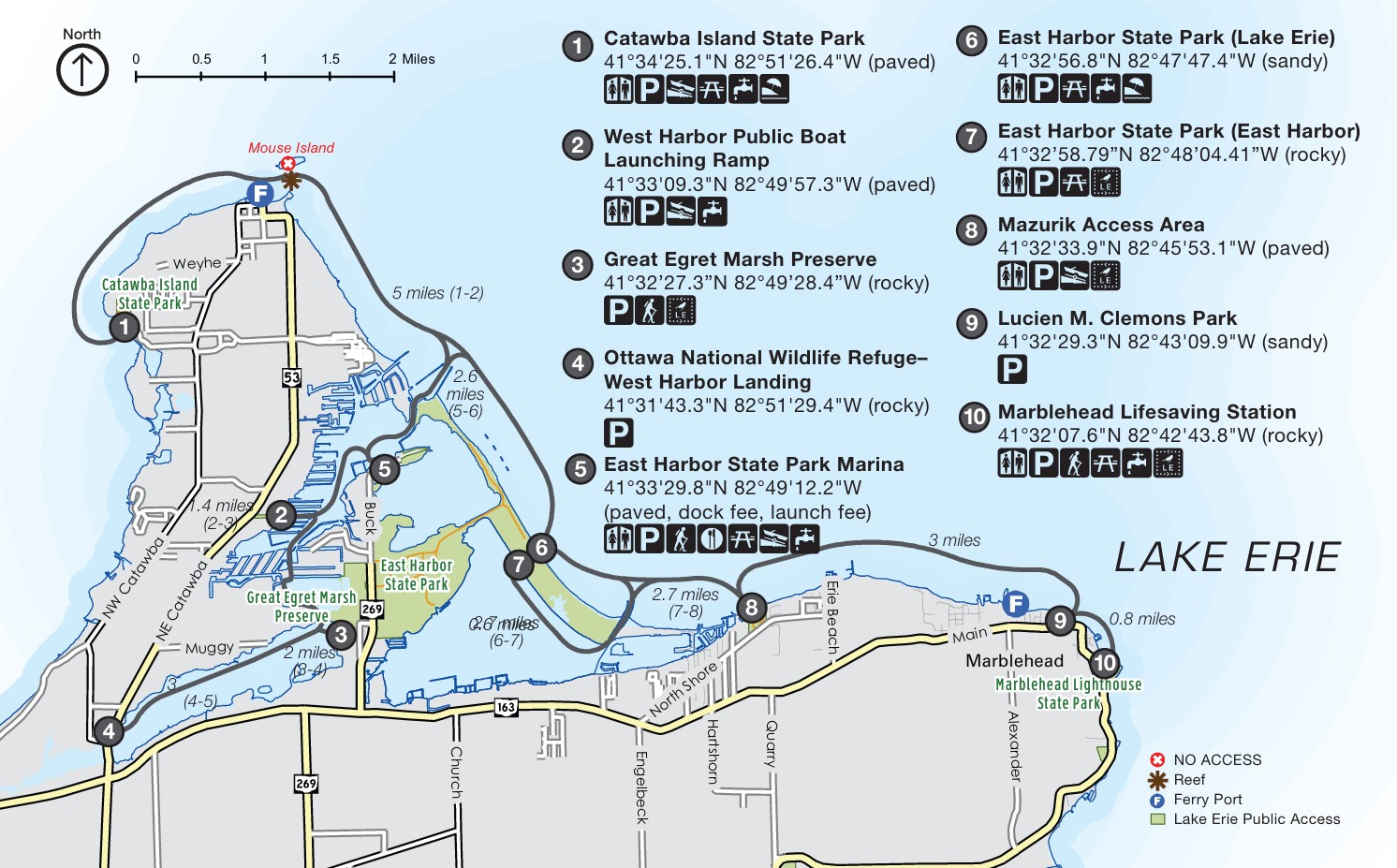
Mainland Water Trail

Best for: variety, marsh scenery, lighthouse views, easier mainland access
The mainland section offers a mix of paddling experiences along the Catawba and Marblehead shoreline, with views of Lake Erie, Sandusky Bay, Kelleys Island, and South Bass Island. Paddlers can find access near Catawba Island State Park, West Harbor, Great Egret Marsh Preserve, Ottawa National Wildlife Refuge West Harbor Landing, East Harbor State Park, Mazurik Access Area, and the Marblehead area.
Highlights
- Rocky shoreline and open lake views
- Marsh habitat and birdwatching opportunities
- East Harbor recreation access
- Marblehead Lighthouse area scenery
Good to know
Use extra caution near ferry docks, busy marinas, rocky shoreline, and exposed sections near Marblehead.
-
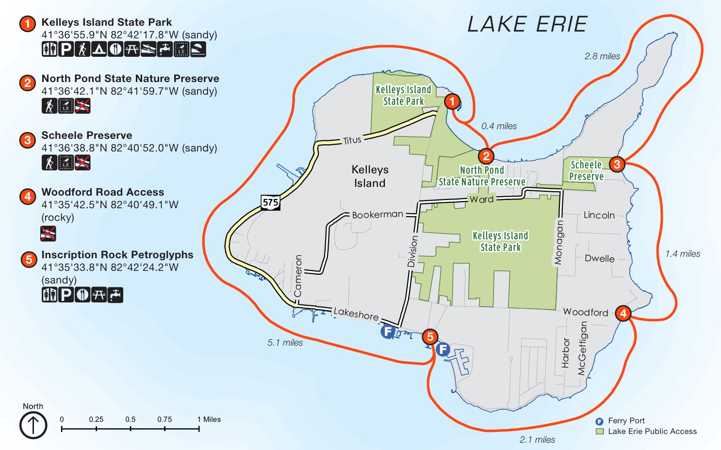
Kelleys Island Water Trail

Best for: nature lovers, shoreline variety, history, a full-island paddling experience
Kelleys Island combines natural beauty with island history. Paddlers can launch near Kelleys Island State Park and explore shoreline features that include sandy beach, North Pond State Nature Preserve, Scheele Preserve, Inscription Rock, village access, and the distinctive limestone landscape of the island’s north shore.
Highlights
- Sand beach launch area
- Wetland and preserve scenery
- Inscription Rock and village access
- Limestone shoreline and alvar habitat
Good to know
Watch for ferry traffic, especially near the southeast side of the island. Cell service may be limited in some areas, particularly on the east side.
-
South Bass Island Water Trail
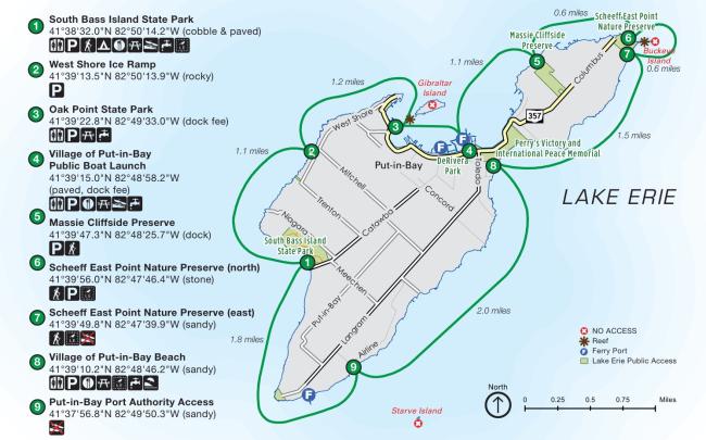
Best for: visitors who want scenery, island landmarks, and nearby dining and attractions
South Bass Island offers one of the most varied paddling experiences in the region, combining cliffs, state parks, village waterfront, and iconic island landmarks. The route passes places such as South Bass Island State Park, Oak Point State Park, Gibraltar Island, the Put-in-Bay harbor area, village waterfront access, and views near Perry’s Victory and International Peace Memorial.
Highlights
- Cliffside paddling and state park scenery
- Views toward Gibraltar Island and Stone Lab
- Easy access to the Put-in-Bay area
- Nearby shops, food, and sightseeing
Good to know
Boat and ferry traffic can be heavy in the harbor during the busy season. Use extra care near docks, harbor channels, and the Miller Ferry area.
-
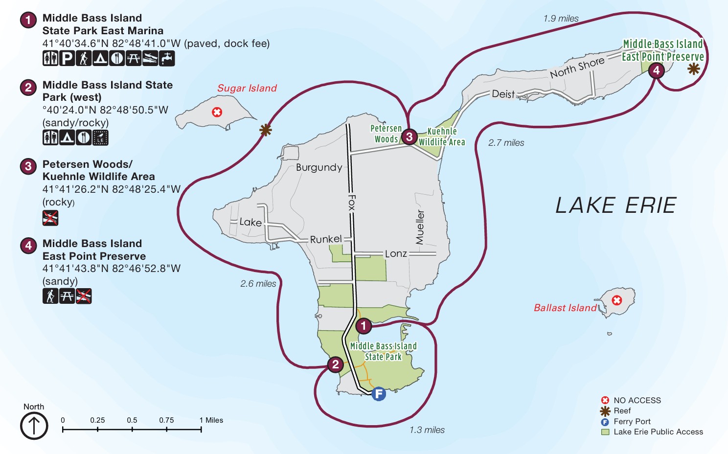
Middle Bass Island Water Trail
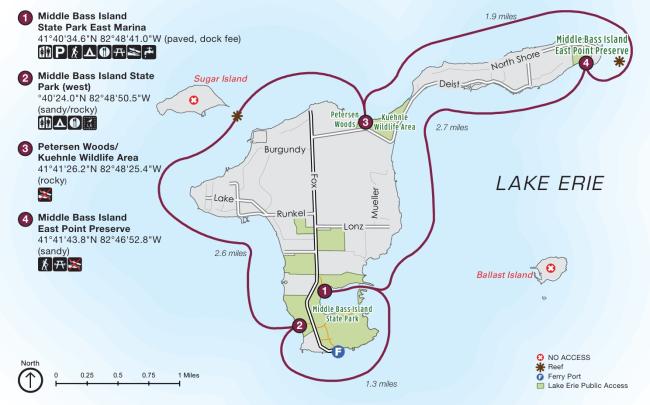
Best for: quieter paddling, scenic shoreline, nature, and island history
Middle Bass Island blends natural shoreline with stories of the island’s grape-growing and winemaking past. Paddlers can launch from Middle Bass Island State Park Marina and explore rocky cliffs, shoreline habitat, historic winery surroundings, wildlife areas, and a more peaceful island setting than some of the busier destinations nearby.
Highlights
- State park marina launch
- Rocky cliffs and shoreline wildflowers
- Historic Lonz Winery area
- Wildlife habitat and birding potential
Good to know
Use caution near the ferry dock and reef areas, and be prepared for changing lake conditions around more exposed shoreline sections.
-
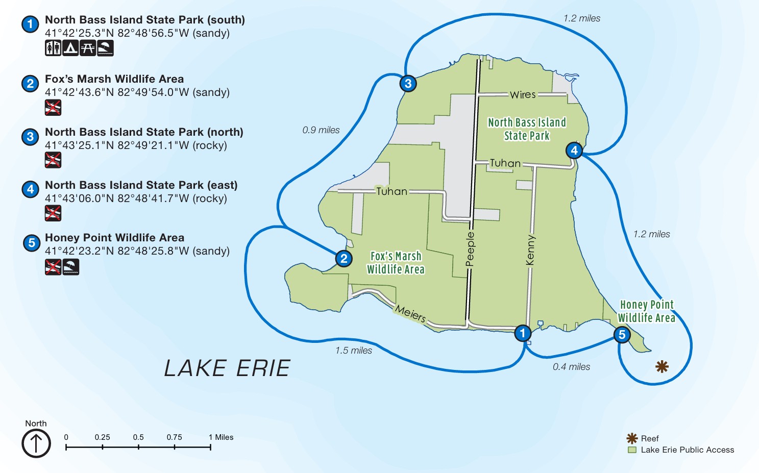
North Bass Island Water Trail

Best for: experienced Lake Erie paddlers seeking remote scenery and undeveloped shoreline
North Bass Island is the most remote and rugged of the trail areas. Much of the island remains undeveloped or agricultural, and paddlers can experience natural shoreline, wetland habitat, and important bird and wildlife areas in a setting that feels quieter and more isolated than the other islands.
Highlights
- Remote island atmosphere
- Wetland and wildlife viewing
- Long stretches of undeveloped shoreline
- A stronger sense of solitude
Good to know
Facilities are limited, and the page’s current guidance describes North Bass as best suited for experienced Lake Erie paddlers because of exposed conditions and more challenging access.
Safety on Lake Erie
Lake Erie rewards paddlers with incredible scenery, but it also demands preparation. Wind, waves, water temperature, ferry routes, and motorboat traffic can change conditions quickly. Visitors should paddle within their skill level, stay close to shore when appropriate, and treat safety planning as an essential part of the trip.
Safety checklist
- Wear a life jacket at all times.
- Check the weather and nearshore lake conditions before launching.
- Be visible with bright clothing and, when appropriate, group paddling and visibility gear.
- Share a float plan with someone reliable.
- Carry water, food, communication devices, a whistle, and basic rescue and first-aid essentials.
- Watch for ferry routes, boat wakes, harbor traffic, rocky shoreline, and backwash.
- Avoid launching if conditions look too hazardous to swim in.
- Check for active algae or water quality advisories before making contact with lake water. These points reflect the current safety guidance published on the page.
Protect the lake while you paddle
The Lake Erie shoreline is a valuable natural and recreational resource, and paddlers play an important role in helping protect it. Visitors can help by packing out trash, respecting wildlife, leaving natural features undisturbed, and following Clean, Drain, Dry practices to reduce the spread of invasive species between waterways.
Easy ways to paddle responsibly
- Pack out all trash.
- Leave rocks, plants, and artifacts where they are.
- Observe wildlife from a distance.
- Keep pets under control, or leave them at home.
- Clean, drain, and dry boats and gear before launching elsewhere.
- Respect public access rules and private property boundaries.
Plan your trip
A little planning goes a long way on Lake Erie. Before heading out, review the trail guide, choose the section that best fits your experience level, confirm launch or ferry details, and check the latest weather and lake conditions. For many visitors, the best trip is not the longest route. It is the one that matches the day’s conditions and their comfort on the water. The official trail guide is available as a downloadable PDF.