Part of our Time Traveler Series
 Did you know that your Gin and Tonic has a connection to Shores & Islands Ohio? The quinine in tonic was essential to survival in the early days of European settlement in the region known as The Great Black Swamp.
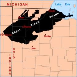
But let’s start at the beginning. If you’ve visited Shores & Islands Ohio, you may have noticed that the region (and most of northwest Ohio) is VERY flat. During the last Ice Age, the Wisconsin glacier scoured the land, flattening much of what was in its path. As the glacier receded, it left sand ridges, as well as its water in a proglacial Lake Maumee (a precursor to Lake Erie). Over time, Lake Erie became its modern shape, and the 1,500 sq. miles of The Great Black Swamp (from Sandusky to Toledo, heading south and west to Fort Wayne, Indiana!) came into being. Land speculators claimed the name was derived from the rich, black soil, but it’s just as likely that it was aptly named for the thick, dark mud, and often dense forest, which made up most of the region.
The Indigenous tribes living nearby used this area for hunting, but had difficulty using it for much else. Between the large layer of mud, dense vegetation, and the unimaginable number of mosquitoes, the swamp, while rich in flora and fauna, was difficult to live within. As Europeans started settling further west beyond the Firelands, they quickly encountered swampland, much of it densely forested, that in places was nearly impassable. One early traveler exclaimed, “They tell me God separated water from land, but here is the place he forgot!” Development of the region was slow due to these constraints, as well the abysmal descriptions written by some War of 1812 soldiers who had travelled the swamp. In addition, many Europeans were wary of the large number of Indigenous people already living in the region.
 Slowly, these settlers cleared the trees and tried to farm any plot of dry land they could find. In an attempt to spur development, in 1827 the building of the Maumee and Western Reserve Road was completed, from Lower Sandusky (now Fremont, Ohio) to Maumee Rapids (now Maumee, Ohio). This road, currently part of modern-day State Route 20, was notoriously referred to as “Mud Pike” and became known as “the worst road on the continent.” The road was better than the earlier corduroy roads made of logs laid side-by-side, but after a few seasons the road began to deteriorate. Along the 31 miles of road were 31 taverns. These were not only points of rest, but frequently housed folks whose business was pulling stuck travelers and wagons out of the mud! Not to be deterred however, many European settlers trudged on and began settling the region.
Along with the mud and wet, another obstacle was the mosquitoes and the diseases they carried. Many new settlers would catch (and even die from) “the shakes.” We now know this as malaria, and it was rampant through the Great Black Swamp region. Death and disease were so common that the Maumee City Express newspaper in 1937 published:
There’s a funeral every day,
without a hearse or pall;
They tuck them in the ground
with breeches, coats and all
 Enter the Gin and Tonic! While malaria was not well understood during the 19th century, Europeans had discovered a treatment in the bark of a Peruvian shrub—quinine. Quinine was used to treat, and help prevent malaria. And it did actually have some effectiveness. Now, tonic of the time contained MUCH more quinine than our modern cocktail version, in fact it would be quite bitter to modern tasters. Quinine was so important that the city of Lima, Ohio was named in honor of Lima, Peru, the source of much of the quinine.
Cholera also plagued the area. Spread primarily through unclean water and sewage, ravaged the region throughout the 1800s. There are many local stories connected to these outbreaks. Benajah Wolcott, the first keeper of the Marblehead Lighthouse, died of cholera after burying bodies that had washed ashore. Sandusky even has a cholera cemetery dating from a terrible outbreak of the disease in 1849.
European settlers used many methods to drain their lands, but once clay was discovered underneath the mud, tiles quickly came into use. In 1859 the Ohio legislature authorized the Ohio Ditch Law, allowing communities to claim land in order to drain the area. You can still see these types of systems in use even today.
 As the water was channeled in to ditches, tributaries, and rivers, rich farmland emerged (maybe those land speculators knew more than we thought?). Canals were built to assist in transporting goods, and quickly the railroads took over as the king of transportation.
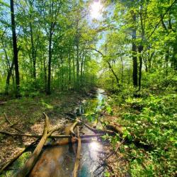
While the original European settlers viewed the draining of the region as progress (and in many ways it was), time has proven that balance is needed between farmland and swamp. Today, areas have been preserved or wetlands reestablished. These wetlands act as filters, trapping and removing harmful chemicals, preventing these toxins from entering the regions rivers and Lake Erie. These efforts not only reestablish the native species in the wetlands, but also help keep Lake Erie clean! If you are interested in seeing what some of the Great Black Swamp once looked like, Magee Marsh Wildlife Area has some of the best remnants and restored wetlands in northwest Ohio.